Period (minutes)
Half-angle of visibility.
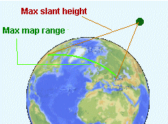
Max. Slant height (km)
Max. Slant range (km)
Max. Map range (km)
Satellite velocity (km/sec)
Max. visibility time (min)
|
- Period The time taken by the satellite to complete one orbit.
- Slant Range The distance between two points on earth, via the satellite.
|
|